California Statewide Special Election November 4, 2025
Official Voter Information Guide
PROP
50
AUTHORIZES TEMPORARY CHANGES TO CONGRESSIONAL DISTRICT MAPS IN RESPONSE TO TEXAS’ PARTISAN REDISTRICTING. LEGISLATIVE CONSTITUTIONAL AMENDMENT.
ANALYSIS BY THE LEGISLATIVE ANALYST
BACKGROUND
U.S. CONGRESS
U.S. Congress. The U.S. Congress is the part of the federal government that makes laws. Congress has two parts: the U.S. Senate and the U.S. House of Representatives (House). Each of the 50 states is represented by 2 senators, with 100 senators in total. The House has 435 members. The number of representatives in the House for each state depends on how many people live in that state. Each member in the House represents an area of the state called a congressional district. California currently has 52 congressional districts. Voters who live in each congressional district elect one member of the House every two years to represent them. The next election for all 435 representatives will be in 2026.
U.S. Census Counts States’ Populations Every Ten Years. The number of people living in an area goes up and down over time. Every ten years, the U.S. Census counts the number of people who live in the U.S. The last census was in 2020, and the next census is in 2030. This count is used to determine how many people live in each state and how many representatives in the House each state gets for the next ten years.
CONGRESSIONAL REDISTRICTING
Each State Draws Congressional District Maps Following the U.S. Census. Every ten years, after the U.S. Census is completed, states draw new congressional district maps to reflect their number of House representatives and where people live. This process is called “redistricting.” Each state decides what process to use to draw its new district maps. When drawing new maps, each state must follow federal laws. For example, each congressional district in the state must represent about the same number of people.
States Typically Do Not Redistrict Sooner Than Every Ten Years. States typically only draw congressional district maps every ten years, unless a court orders changes to comply with the law. In August 2025, however, the Texas Legislature passed a bill to adopt new maps for the 2026 elections without a court order. Several other states also are considering changes to their maps before the 2026 elections.
Congressional Redistricting in California. State legislatures draw congressional district maps in most states, but some states use commissions to do this job. Before 2010, the California Legislature drew the state’s congressional district maps. In 2010, California voters gave this job to an independent commission known as the California Citizens Redistricting Commission (Commission). The Commission includes 14 members: 5 Democratic members, 5 Republican members, and 4 members who are not registered with either of those political parties. When the Commission draws new congressional district maps, it must follow federal and state laws. For example, state law requires, among other things, the Commission to avoid splitting up neighborhoods or local communities of interest to the extent possible. State law also prohibits the Commission from considering political parties, current office holders, or people running for office when it draws the maps.
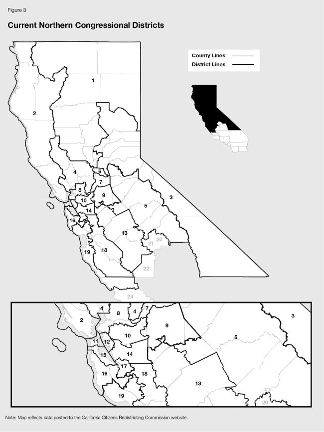
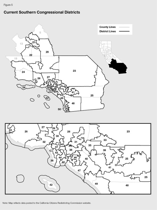
Current California Congressional Districts. The Commission drew the current maps for California’s 52 congressional districts. These maps were based on the 2020 U.S. Census and have been used since the 2022 congressional elections.
PROPOSAL
CALIFORNIA’S CONGRESSIONAL DISTRICT MAPS
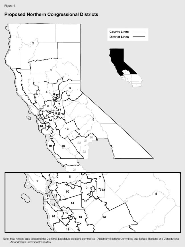
Use Legislatively Drawn Congressional District Maps Until After the Next Census. Proposition 50 replaces California’s current congressional district maps with new, legislatively drawn maps. (The total number of districts would not change.) Proposition 50’s maps must follow federal law, but they are not required to follow the state requirements placed on the Commission. The state would use Proposition 50’s maps for congressional elections starting in 2026. The state would use these maps until the Commission draws new district maps, following the 2030 U.S. Census.
NATIONAL CONGRESSIONAL REDISTRICTING
Call for Change in Federal Law. Proposition 50 asks the U.S. Congress to change federal law and propose an amendment to the U.S. Constitution to require redistricting be done by “fair, independent, and nonpartisan redistricting commissions nationwide.” Proposition 50 expresses voter support for this idea, but does not change federal law or require any particular action of Congress or the California Legislature.
FISCAL EFFECTS
Minor One-Time Costs to County and State Elections Officials. Counties run elections, and the state oversees them. Because most congressional districts in California would change at least some under the new maps, county and state elections officials would need to update election materials. This would result in one-time costs to counties of up to a few million dollars statewide and one-time costs to the state of roughly $200,000. The state amount is much less than one-tenth of 1 percent (0.1 percent) of the state’s roughly $220 billion General Fund budget. (The General Fund is the account the state uses to pay for most public services, including education, health care, and prisons.)
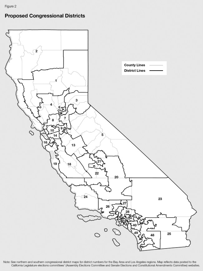
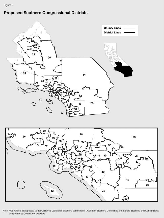
CURRENT AND PROPOSED CONGRESSIONAL DISTRICT MAPS
This section shows maps of the current and proposed congressional districts (1) statewide, as shown in Figures 1 and 2; (2) in the northern part of the state, as shown in Figures 3 and 4; and (3) in the southern part of the state, as shown in Figures 5 and 6. A description of the census blocks represented by each district in the proposed maps can be found at the following website: https://leginfo.legislature.ca.gov/faces/billNavClient.xhtml?bill_id=202520260AB604
Visit sos.ca.gov/campaign-lobbying/cal-access-resources/measure-contributions/2025-ballot-measure-contribution-totals for a list of committees primarily formed to support or oppose this measure.
Visit fppc.ca.gov/transparency/top-contributors.html to access the committee's top 10 contributors.

Figure 2 in the analysis of Proposition 50 contained a typographical error. District 27, which is to the right of District 26, was incorrectly labeled as District 22. This typographical error has been corrected.